eC2: Indonesia: policy recommendations on operationalization of a national urban flood resilience program and technical study on social inclusion

Deadline: 13-Aug-2020 at 11:59:59 PM (Eastern Time – Washington D.C.)floods

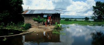
Indonesia is one of the most disaster-prone countries in the world, exposed frequently to a range of hazards. Floods dominate the natural hazard figures in most metropolitan areas, often accounting for almost half of all events occurred. Over sixty percent of Indonesias districts are exposed to a high risk of flooding, caused by a range of factors including rapid urbanization and poor construction practices; poor drainage design and insufficient (or infrequent) maintenance; increasing effects of climate change (e.g., sea level rise); and coastal infrastructure that needs upgrading. A balanced and cross-sectoral approach to urban flood risk management, encompassing both structural and non-structural measures and green infrastructure, is needed to address these challenges. Increased and systematic investments to reduce urban flood risk need to be integrated with urban development projects, as well as the institutionalization of a maintenance and improvements regime of urban drainage and flood infrastructure. Since 2018, the World Bank has been providing technical assistance to the government of Indonesia in support of a national urban flood resilience program that addresses the above.

Continue reading

Integrated urban flood risk management: Learning from the Japanese experience

In the summer of 1742, two typhoons swept across Japan in quick succession, bringing water_quality_mason_jartorrents of heavy rain and flooding major rivers. Records from a young monk who witnessed the floods describe a muddy wave destroying levees and sweeping through villages. As levees and rivers collapsed, floodwaters rose in Edo, Japan’s largest c

ity and political capital, abating o

nly days later, and

resulting in fatalities of a reported 6,000 in the city.
Continue reading

eC2: Understanding urban flood risk in Jujuy, Argentina

Deadline: 31-Oct-2018 at 11:59:59 PM (Eastern Time – Washington D.C.)

The World Bank is seeking consultant services to analyze urban flood risk in the city ofpexels-photo-831890.jpeg San Salvador de Jujuy, Argentina, as part of the World Bank’s City Resilience Program. Specifically, the consultancy will focus in the Chijra River. The expected tasks include:
1. Diagnosis of current situation including compiling, preparing, complementing and / or updating existing information.
2. Develop a Digital Terrain Model for the whole basin using the existing information.
3. Analysis of hydrological aspects; mainly the review of the studies available within the basin and close to it, considering the historical values and the climatic tendencies indicated in the recent history.
4. Construction of a 1D hydrodynamic model for the area based on the MDT.
5. Evaluate the possibility of calibration of the models with background information.
6. Prepare the base cartography of the area based on the available information.
7. Define the design events for the exploitation of the hydrodynamic model.
8. Draw the flood lines for the different scenarios.
9. Analyze sediment transport at basin level.
10. Identify erosion / sedimentation zones.
11. Identify existing infrastructures that affect natural runoff.
12. Identify population and infrastructure exposed to risk.
13. Identify mitigation works for both floods and erosion / sedimentation phenomena.

The assignment and all deliverables will be in Spanish.

Continue reading

eC2: Strengthening Natural Hazard Resilience in Yemen’s Major Cities

Deadline: 14-Aug-2018 at 11:59:59 PM (Eastern Time – Washington D.C.)

The World Bank will carry out a multi-hazard assessment in Sanaa, Aden and 2286002741_fdde7127e5_bHodeidah. These cities are exposed to hazards such as coastal and urban floods, seismic activity, tsunamis, volcanoes and water scarcity.
The consultancy will develop hazard maps, assessing individual hazards and their interdependence. The assessment will provide spatial insight into the hazards footprints in the form of fully licensed, GIS compatible datasets. It will gauge the exposure of each of the cities to hazard risks, considering their location, attributes, and when possible vulnerabilities and the value of their assets.

Continue reading

eC2: Community Mapping Facilitation and Training for Tanzania Urban Flood Risk Exposure

Deadline: 10-Apr-2017 at 11:59:59 PM (Eastern Time – Washington D.C.) water
To extend the community mapping planning, training, coordination and analytical support of the Ramani Huria program of Tanzania into a new phase for 2017 2019. Support to 200+ university students on placement in industry program in deploying openstreetmapping with local government and communities in Dar es Salaam and Mwanza with a focus on unplanned and flood-prone urban environments. 

Continue reading